Fill out the form with your application and requirements and we will find the right product for your needs or continue scrolling for the Product Catalog.
NEW FormLabs Form 4L - BIG Parts, Blazing Fast. Order Yours Today!


Fill out the form with your application and requirements and we will find the right product for your needs or continue scrolling for the Product Catalog.
NEW FormLabs Form 4L - BIG Parts, Blazing Fast. Order Yours Today!
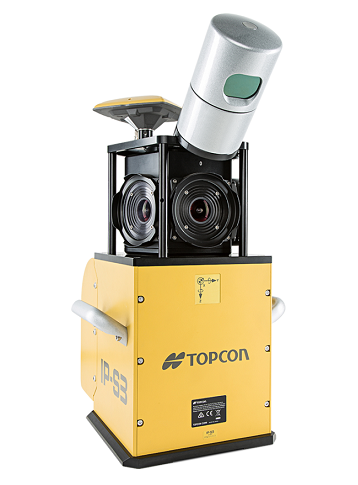
The IP-S3 HD1 bundles the longstanding experience of Topcon in mobile mapping systems in a small package. The system overcomes the challenges of mapping 3D features at a high level of accuracy. Accurate vehicle positions are obtained using three technologies: A dual frequency GNSS receiver establishes a geospatial position; an Inertial Measurement Unit (IMU) provides vehicle attitude; and connection to the vehicle or external wheel encoder obtains odometry information. These three technologies work in tandem to sustain a highly accurate 3D position for the vehicle even in locations where satellite signals can be blocked by obstructions such as buildings, bridges, or tree lines.
The IP-S3 HD1 system includes a single sensor head of LiDAR containing lasers oriented to cover roadside features up to 100 meters away. The panoramic, high-resolution 30 megapixel camera is included to collect images in fixed distance intervals. All sensor inputs are recorded and time stamped to a common clock driven by the IP-S3 HD1.
Use the powerful, all-in-one Mobile Master Field and Office software suite to collect and process geo-referenced LiDAR and/or digital imaging data into a colorful 3D representation which can be exported to third party software. Matching techniques and ground control functionality optimizes precision and absolute accuracy. Mobile Master software provides a simple interface for combining, viewing and working with your various sensor data collected from the IP-S3 HD1.
The IP-S3 HD1 quickly provides high-accuracy data and dynamic imaging for any mapping project. The easily mounted vehicle system can map data at normal travel speeds for roadway surface condition assessments and roadside feature inventories. Safety is increased by removing pedestrians from the travelled lanes. Other applications include pipelines, utilities, as-builts, construction progress monitoring and risk management.
The high-definition laser scanner included with the IP-S3 HD1 collects 700,000 points-per-second at a range of 100 meters. The scanner has a 360° horizontal field of view and a 30° vertical field of view to increase data collection coverage and minimize laser shadowing. With those features, the system remains lightweight at under 18 kg making it the lightest and most compact high-precision mobile mapping system available today.
TOPCON Mobile Mapping System IP-S3 HD-1 Product video