RIEGL VZ-600i TERRESTRIAL LASER SCANNER
RIEGL Logo

Exceeding your expectations

RIEGL SYNERGY

The New Focus Core Laser Scanner is now only AUD $39,800 +gst PLUS we have a couple of Ex-Demo Focus Premiums that must go, AND we are offering FREE Service Plans for all Focus Premium Scanners sold this month!

LAST DAYS - fill out the form below to Save Now.

Want to learn more about REIGL's latest generation of professional Terrestrial Laser Scanners?

Let’s work together to find the right solution for your needs, tomorrow and for the years ahead.


Our Clients

Higgins
heb
Downer
Fulton Hogan
Fletcher
Boeing
PorterGroup
Cardno
NZTransport
Komatsu
RIEGL VZ-600i TERRESTRIAL LASER SCANNER

Ultimate Scanning Performance

Introducing the RIEGL VZ-600i: Your Ultimate Solution for Indoor and Outdoor 3D Mapping. With a broad range capability, this powerful tool offers precision and efficiency like never before. Capture 3D position accuracy of 3 mm in less than 30 seconds. It's lightweight, with a weight of less than 6 kg (13 lbs), making it perfect for any on-the-go situation. Equipped with three internal cameras and GNSS integration, this device is a must-have for professionals in the AEC, BIM, as-built surveying, and forensic industries.

Whether you're in construction, archaeology, or forestry, the RIEGL VZ-600i is the tool that will revolutionise your workflow. Experience the future of mapping technology today.

oar2

Boost Your Productivity with One-Touch Efficiency

With our cutting-edge technology, you can achieve an impressive 60 scan positions per hour, making your work more efficient than ever before. Our One-Touch button operation simplifies the scanning process, saving you time and effort.

Introducing the RIEGL VZ-i Project Map App, designed to keep your scan projects on track. Stay in control as you monitor and manage your scans effortlessly.

Our advanced system allows you to acquire both scan and image data at the same time, ensuring you have a comprehensive view of your projects.

No more manual registrations! Our innovative technology offers real-time on-board automatic registration, streamlining your workflow and freeing up your valuable time for more important tasks.

Experience the convenience of our One-Touch Processing Wizard in RiSCAN PRO. This powerful tool automatically generates detailed PDF-reports, saving you hours of manual work.

Elevate your productivity and efficiency with our synergy professional solutions. Try it today and see the difference it can make in your work.

Ultimate Performance

  • broad range capability  (0.5 m up to 1000 m)
  •  
  • 5 sec scan time  for low-resolution overview scans
  •  
  • 30 sec scan time  for 6 mm resolution @ 10 m distance
  •  
  • pulse repetition rate up to 2.2 MHz
  •  
  • 3D position accuracy up to 3 mm @ 50 m
  •  
  • scan speed up to 420 lines/sec
  •  
  • high-speed data download of  up to 500 MB/sec

RIEGL VZ-600i Laser Scanner

Key Components


Screenshot 2023-11-10 at 5.45.12 PM


How we can help

 For 40 years, we have partnered with industry leaders to help them improve their work with our 3D measurement, imaging and realisation software solutions.

Let us do the same for you.

High Productivity Rapid Data Acquisition

Key Features of rapid data acquisition with the RIEGL VZ-600i:

  • up to 60 scan positions per hour
  • 6 mm resolution @ 10 m distance
  • simultaneous image acquisition
  • real-time on-board automatic registration, no tablet required
  • no tie points necessary for robust registration
  • remote control by the use of the RIEGL VZ-i Series App (for iOS and Android)
  • monitor registration with the VZ-i Project Map App (direct from the scanner)


Screenshot 2023-11-10 at 6.07.55 PM Screenshot 2023-11-10 at 6.08.39 PM Screenshot 2023-11-10 at 6.08.20 PM Screenshot 2023-11-10 at 6.08.55 PM

RIEGL VZ-600i Screen or VZ-i Series App

VZ-i Project Map App

RIEGL VZ-600i Screen or VZ-i Series App

VZ-i Project Map App

Choose the Hardware Solution for your Plans

Focus Core

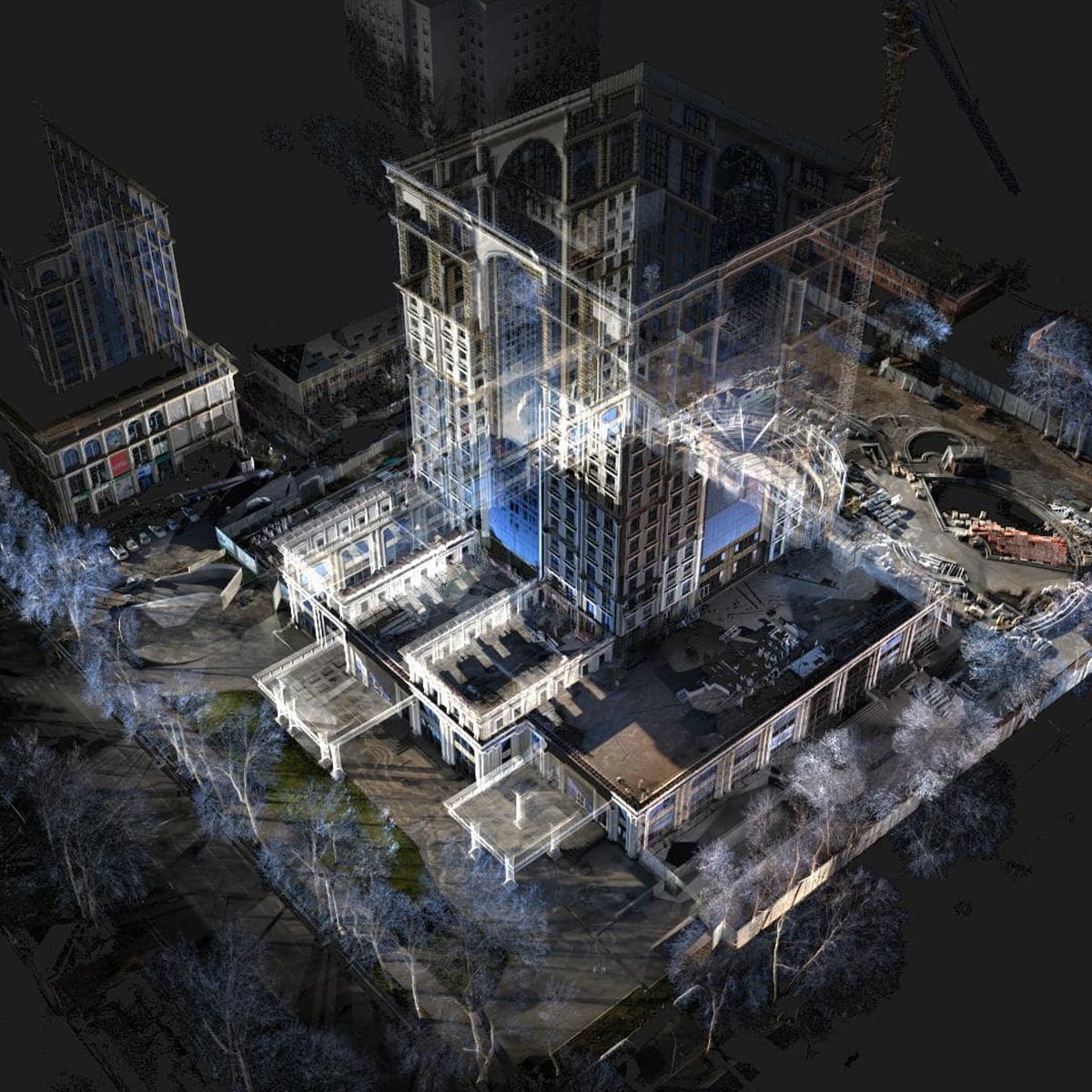
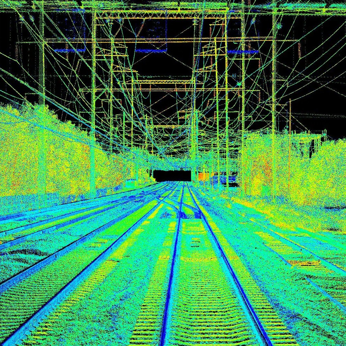
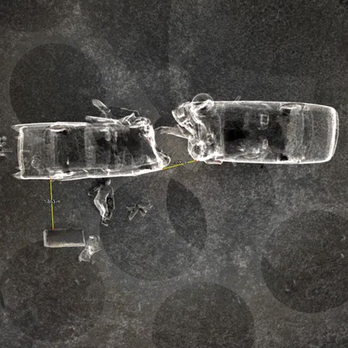
A cost-competitive solution for fast colorised scans that best balances speed, accuracy and price

The FARO® Focus Core Laser Scanner is the latest release in the company’s reality-capture device portfolio.

Focus Core enables fast colorized 3D scans and delivers a cost-competitive solution for construction, operations and public safety professionals eager to strike the optimal balance between scanning accuracy and speed, reducing time spent on site or on scene, while eliminating materials waste and personnel bottlenecks.

Focus Core

70-meter range with a distance accuracy of 2mm
Comparison

Capturing the measurements of a large building, facility, or crash/crime scene with conventional documentation can take days or weeks, and even then, the data might be incomplete. But the FARO Focus Premium and FARO Focus Core create accurate, photorealistic 3D representations of any environment or object in just a few minutes – even in the most extreme outdoors conditions.


Focus Core
Focus Premium 70
Focus Premium 150
More Details
Max Speed
Up to 0.5 MPts/sec
Up to 2 MPts/sec
Up to 2 MPts/sec
3D Accuracy*
3mm@10m, 4mm@25m
2mm@10m, 3.5mm@25m
2mm@10m, 3.5mm@25m
Ranging Error*
±2 mm
±1 mm
±1 mm
Angular Accuracy*
19 arcsec
19 arcsec
19 arcsec
LaserHDR
Yes
Yes
Yes
Temperature Range*
Operating: 5°-40°C
Ext Operating: -10°-55°C
Storage: -10°-60°C
Operating: 5°-40°C
Ext Operating: -10°-55°C
Storage: -10°-60°C
Operating: 5°-40°C
Ext Operating: -10°-55°C
Storage: -10°-60°C
Focus Premium

The Ultimate in 3D Data Capture

For best on-site data capture, Focus Premium connects with the new FARO Stream app, bridging FARO hardware to the FARO Sphere cloud environment. Pre-registration scans are fed directly into the cloud, so jobs can be done more efficiently. Users can also benefit from Hybrid Reality Capture™, powered by Flash Technology™.

The new scan mode for the FARO Focus Premium Laser Scanner is available as an add-on subscription that combines the accuracy of a 3D scan with the speed of a panoramic camera – enabling fast scans in under 30 seconds with colorized 360° images that save up to 50% scanning time.

Focus Premium 350
Focus Premium 150
Focus Premium 70
Availability
Range
0.5 – 350m accuracy ±1mm
0.5 – 150m accuracy ±1mm
0.5 – 70m accuracy ±1mm
Speed
Up to 2 MPts/sec
Up to 2 MPts/sec
Up to 2 MPts/sec
Warranty
2 years
2 years
2 years

Range
0.5 – 350m accuracy ±1mm
0.5 – 150m accuracy ±1mm
0.5 – 70m accuracy ±1mm
Speed
Up to 2 MPts/sec
Up to 2 MPts/sec
Up to 2 MPts/sec
Warranty
2 years
2 years
2 years

Range
0.5 – 350m accuracy ±1mm
0.5 – 150m accuracy ±1mm
0.5 – 70m accuracy ±1mm
Speed
Up to 2 MPts/sec
Up to 2 MPts/sec
Up to 2 MPts/sec
Warranty
2 years
2 years
2 years

Range
0.5 – 350m accuracy ±1mm
0.5 – 150m accuracy ±1mm
0.5 – 70m accuracy ±1mm
Speed
Up to 2 MPts/sec
Up to 2 MPts/sec
Up to 2 MPts/sec
Warranty
2 years
2 years
2 years

Range
0.5 – 350m accuracy ±1mm
0.5 – 150m accuracy ±1mm
0.5 – 70m accuracy ±1mm
Speed
Up to 2 MPts/sec
Up to 2 MPts/sec
Up to 2 MPts/sec
Warranty
2 years
2 years
2 years

Not sure which is Right Solution for You?

Extreme Versatility - Key Applications

RIEGL BIM Construction

BIM & Construction

Experience faster and more accurate data acquisition with our cutting-edge technology. Our verifiably precise scan data ensures unmatched accuracy, surpassing 10 mm for digital twins. Perfect for large-scale projects with hundreds of scan positions.

Ensure impeccable precision in design build tilt wall/panel construction, blockouts & sleeves locations, and vertical wall plumbness with our inspection and verification services. Ideal for preconstruction planning and optimizing large-scale ground grading and post-roadway construction projects.

Unlock the full potential of your projects with our high-speed data acquisition and inspection solutions.

RIEGL Rail scan

Surveying and Mapping

Efficiently map any environment with precision and accuracy for planning, design, and traditional surveying. Our streamlined registration process seamlessly connects survey control, providing comprehensive reporting in PDF format.

Experience the power of robotic operation, utilising advanced onboard sensors and ROS technology for rapid and consistent data acquisition. Our RIEGL VMR Robotic Rail Laser Scanning System is perfect for railway applications.

Discover the future of mapping and surveying with our state-of-the-art technology.

Join us in harnessing the synergy of precision and efficiency.

RIEGL Forenics

Public Safety and Forensics

RIEGL scanners are known for their fast data capture capabilities, making them ideal for applications where time is of the essence, such as public safety and forensics.

The RIEGL VZ-600i, for example, can capture up to 60 scan positions per hour, with a resolution of 6mm at 10m distance.

This means that public safety officials and forensic investigators can quickly and efficiently capture detailed 3D data of crime scenes and accident sites, which can be used to generate accurate and detailed reconstructions.

Capture detailed 3D data of evidence, such as tire tracks, footprints, and bullet holes. This data can be used to create accurate and detailed diagrams and animations, which can be used as evidence in court.

RIEGL Forestry

Forestry and Agriculture

The advantage of Time of FLight (ToF) scanners is that they can measure distances to multiple targets simultaneously. This is because the scanner uses a modulated light source, allowing it to distinguish between photons that are reflected from different targets. This capability is known as multi-target response.

Multi-target response is particularly useful in applications where there is a lot of occlusion, such as in forests or jungles. When an object is occluded, it means that it is partially or completely blocked from view by another object. 

Another advantage of ToF scanners is that they can penetrate vegetation. This is because infrared and near-infrared light are less scattered and absorbed by plants than visible light. This capability makes ToF scanners ideal for use in applications such as forestry and agriculture.

RIEGL VZ-600i - Ultimate Scanning Performance

Range Measurement Performance

Measuring Principle / Mode of Operation time of flight measurement, echo signal digitisation, online waveform processing
Laser Pulse Repetition Rate (PRR) – (peak) 1) 2200 kHz 1200 kHz 600 kHz 140 kHz

Max. Measuring Range 2) natural targets ρ ≥ 90 %
natural targets ρ ≥ 20 %

220 m
100 m
320 m
150 m
420 m
200 m
1000 m
450 m
Minimum Range 3) 0.5 m 0.5 m 0.5 m 1 m
Max. Number of Targets per Pulse 4) 5 10 15 15
Ranging Accuracy 5) 7) 5 mm
3D Position Accuracy 8) 3 mm @ 50 m, 5 mm @ 100 m
Precision 6) 7) 3 mm (1 mm with extended scan time and reduced maximum measuring range)
Laser Wavelength near-infrared, invisible
Laser Beam Divergence 0.35 mrad 9/ 0.25 mrad 10)


Scanner Performance

  Vertical (Line) Scan Horizontal (Frame) Scan
Scan Angle Range total 105° (+65° / -40°) max. 360°
Scanning Mechanism rotating multi-facet mirror rotating head
Scan Speed 4 lines/sec to 420 lines/sec 0°/sec to 360°/sec 11)
Performance scan time less than 30 seconds for “Panorama_6mm”
(approx. 30 Mio measurements)
6 mm resolution @ 10 m distance,
up to 60 scan positions per hour
(including scan and image acquisition with real-time onboard registration)
Angular Step 12)
)h (vertical), )n (horizontal) User defineable Resolution
0.0007° ≤ )h ≤ 0.54°
between consecutive laser shots
0.0015° ≤ )n ≤ 0.86°
between consecutive scan lines
Angular Accuracy 13) 0.0028° (10 arcsec) 0.0028° (10 arcsec)
Angle Measurement Resolution better 0.0007° (2.5 arcsec) better 0.0005° (1.8 arcsec)
Orientation Sensors integrated 3-axis accelerometer, 3-axis gyroscope, 3-axis magnetometer (compass), barometer
GNSS Receiver integrated L1 GNSS receiver,
optional external RIEGL GNSS RTK receiver
Waveform Data Output (optional) providing digitized echo signal information for specific target echoes
Data Storage integrated SSD 2 TByte,
removable CF-Express card 512 GByte (1 TByte optionally available), automatic sync while scanning
Cloud Storage Amazon S3, FTP-Server, Microsoft Azure
On-board Registration automatic scan data registration as background process while scanning


1)   Rounded values.

2)   Typical values for average conditions. Maximum range is specified for flat targets with size in excess  of the laser beam diameter, perpendicular angle of incidence, and for atmospheric visibility of 23 km. In bright sunlight, the max. range is shorter than under overcast sky.
3)   Minimum range specified for vertical zenith angles from 25 deg to 130 deg, resp. 105° vertical field of view.
4)   If more than one target is hit, the total laser transmit- ter power is split and, accordingly, the achieveable range is reduced.
5)   Accuracy is the degree of conformity of a measu- red quantity to its actual (true) value.
6)   Precision, also called reproducibility or repeatability, is the degree to which further measurements show the same result.
7)   1 sigma @ 100 m range under RIEGL test conditi- ons.
8)   1-sigma value, based on target modelling, under RIEGL test conditions.
9)   Measured at the 1/e2 points. 0.35 mrad corre- sponds to an increase of 35 mm of beam diameter per 100 m distance.
10) Measured at the 1/e points. 0.25 mrad corresponds to an increase of 25 mm of beam diameter per 100 m distance.
11)  Frame scan can be disabled, providing 2D scanner operation.
12) Selectable.
13) 1-sigma value, based on target modeling, under RIEGL test conditions

Scanner Control

via Laser Scanner 7 inch touch screen, 1280 pixel x 800 pixel
via Mobile Device(WiFi) RIEGL VZi-Series-App, available for iOS and Android
via ROS ROS (Robot Operation System) driver available


Camera

Internal Camera
Anonymization of Image Data
3 x 12 MPix CMOS color cameras, FOV 115° x 40° (v x h)
optional on-board face detection and automatic facial blurring in real-time before image storage
External Camera (optional) detachable SONY α7R IV
Panorama Camera (optional) detachable RICOH Theta Z1


General Technical Data

Internal Power Supply 2 x Li-Ion hot-swap rechargeable batteries
99 Wh, up to 90 minutes operating time, each
<0.5 kg / 1.1 lbs  each
External Power Supply input voltage 11 - 34 V DC
Power Consumption typ. 60 W, max. 70 W (without external devices)
Main Dimensions (width x height x depth) 173 mm x 305 mm x 184 mm
Weight Scanner without battery <6 kg / 13 lbs
Humidity max. 80 % non condensing @ +31°C
Protection Class IP64, dust- and splash-proof
Temperature Range Storage / Operation
Low Temperature Operation
-10°C up to +50°C / 0°C up to +40°C: standard operation
-20°C: continuous scanning operation if instrument is powered on while internal temperature is at or above 0°C and still air
-40°C: scanning operation for about 20 minutes if instrument is powered on while internal temperature is at or above 15°C and still air

Swift Data Processing

Produce end deliverables with the Data Processing Software RiSCAN PRO and its One-Touch Processing Wizard.

RiSCAN Data POrocessing b 1200x700


Key Features of the Data Processing Software RiSCAN PRO:

  • One-Touch Processing Wizard
  • fast download from the CF-Express Card (up to 500 MB/sec)
  • automatic filtering (e.g. dynamic objects, deviation, reflectance, multiple targets, etc.)
  • optimization of the camera mounting calibration
  • automatic colorisation of the point cloud
  • generation of ortho plots (e.g. GeoTIFF)
  • export as RiPANO project, e57 project, LAS, etc.
  • automatic generation of PDF report

Optional Equipment

RIEGL Camera GNSS Antenna
RTK GNSS antenna and/or external camera

With an attached RTK-GNSS antenna, the absolute positioning accuracy can be improved to 1-2 cm. The correction data is then received via WLAN.

Charger Batteries
Charger for 2 or 6 batteries

The chargers are designed for 2 or 6 batteries. They can be supplied from the 12  V DC voltage of a vehicle as well as from a corresponding 110/230V AC power supply module. The advantage of the 2-fold charger lies in the size and weight, of the 6-fold charger in the possibility of continuous scanning over 24 hours (with simultaneous charging of the empty batteries).

Jay Leno's Garage

What Customers say...

Jay Leno's Garage

Jay Leno, “FARO, this company will change the way we manufacture."

What Our Customers Say

Today, the world moves extremely fast. The interest level of filtering through pages of information to find out if a company or product is a good fit is waning quickly. 

“John and the team at Web Canopy Studio get what it takes to help companies grow successfully. Their growth-driven design and inbound marketing focus are a best practice-approach to building better businesses.”

Michael Scott

“John and the team at Web Canopy Studio get what it takes to help companies grow successfully. Their growth-driven design and inbound marketing focus are a best practice-approach to building better businesses.”

Michael Scott

“John and the team at Web Canopy Studio get what it takes to help companies grow successfully. Their growth-driven design and inbound marketing focus are a best practice-approach to building better businesses.”

Michael Scott

“John and the team at Web Canopy Studio get what it takes to help companies grow successfully. Their growth-driven design and inbound marketing focus are a best practice-approach to building better businesses.”

Michael Scott