RIEGL | Antarctic Research Projects
RIEGL technology has been implemented in a series of projects by the U.S. Army Corps of Engineer’s Cold Regions Research and Engineering Laboratory (CRREL) conducted in collaboration with InfraTec. This project was under a program sponsored by the National Science Foundation (NSF). These efforts focused on improving the energy efficiency and structural resilience of United States research stations in Antarctica, including Palmer, McMurdo and the Amundsen-Scott South Pole Station—some of the most extreme and remote environments on Earth.
Facing the Harshest Conditions on the Planet
Antarctica presents a unique challenge for infrastructure: extremely low temperatures, high winds, and heavy snowfalls continuously stress the buildings. Maintaining operational efficiency and minimising energy consumption in such conditions requires a deep understanding of building performance. Thermography, when paired with precise 3D spatial data, offers a powerful tool for diagnosing heat loss and structural vulnerabilities.
Thermal Camera Meets LiDAR System
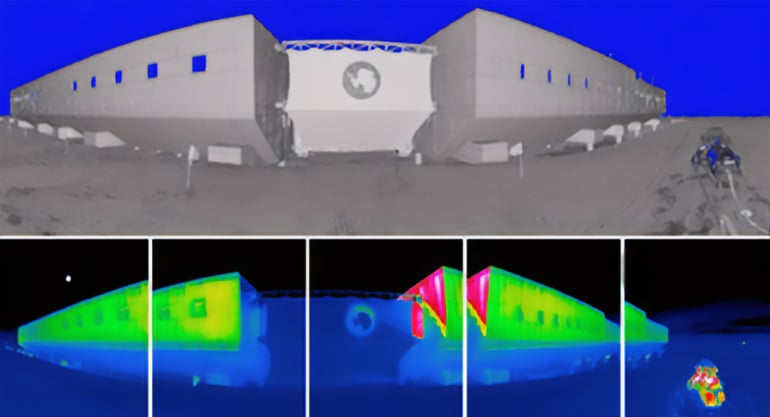
 In 2015 at Palmer Station, the team deployed a VarioCAM HD head 880 thermal camera mounted on a RIEGL VZ-1000 terrestrial laser scanner atop a survey tripod, enabling synchronised high-resolution thermal and spatial data collection. The system was later used at Amundsen-Scott South Pole Station in 2017—where it operated in temperatures as low as -30°C—and at McMurdo Station in 2020. A custom thermal jacket, used only at the South Pole, ensured reliable performance in extreme cold, while a dedicated power system maintained consistent operation.
The goal: to produce a thermal infrared point cloud and a full 3D model of the building envelope, revealing areas of heat loss and structural stress.
Key Findings
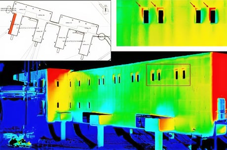
Example data from a scan position in front of South Pole Station. Top: view of LIDAR data, colored by surface reflectance. More reflective surfaces backscatter stronger laser returns. Bottom: Set of thermography data collected with the VarioCAM HD, colored by a (-45 … -5) °C color scale. A 40 % overlap between subsequent images is shown
- A 3D model of the South Pole Station’s west wing revealed temperature anomalies around certain windows, suggesting potential heat loss.
- The elevated station’s adjustable support columns—designed to compensate for shifting ice and snow accumulation—were successfully modeled and analysed.
- The thermal-LiDAR integration identified minor structural insulation panel (SIP) fit issues, thermal bridging, and window performance variations.
- Entrance doorways showed minimal heat loss, validating the use of cold-store door designs.
Data Processing and Software
- Thermal data was processed using IRBIS® 3 professional software.
- LiDAR data was managed with RIEGL’s RiSCAN PRO, ensuring seamless integration of spatial and thermal datasets.
Multi-Station Research Timeline
The research campaign spanned three major U.S. Antarctic stations:
- 2015 – Palmer Station: Key findings in this article were referenced from this initial project. Initial thermographic data collection began here, establishing baseline methodologies. More information on this research project can be found in this report
- 2017 – Amundsen-Scott South Pole Station: Further research was conducted to expand upon the 2015 Palmer Station project. The focus shifted to this elevated station, where the building rests on a slowly moving ice sheet, requiring regular structural adjustments. More information on this research project can be found in this report
- 2020 – McMurdo Station: Finally, the most recent phase of the project continued the integration of thermal and spatial data expanding with UAS operations with the RIEGL VUX-1UAV LiDAR payload on the RIEGL RiCOPTER platform. More information on this research project can be found in this report
The Cold Regions Research and Engineering Laboratory (CRREL) is a leading center for cold regions research, supporting the U.S. Army Corps of Engineers, the Department of Defense, and national interests for over 60 years. With headquarters in Hanover, New Hampshire, and facilities in Alaska, CRREL’s team of 250+ experts tackles challenges in extreme environments through advanced capabilities like a permafrost tunnel, LiDAR research, and ice adhesion testing. CRREL collaborates with other ERDC labs and partners across government, academia, and industry to enhance safety and efficiency in cold region operations.